Map options dialog box
This topic describes the purpose of the Map options dialog box and all the settings and buttons on it.
NOTE: This dialog box is only applicable if you are using the ESPA analysis center.
The Map options dialog box allows you to set the zoom level used on the ESPA analysis center map when you click Zoom on any of the tabs on the Data view. It also allows you to set values for how the sector beam widths and radiuses are displayed on the map. You can also set the default values for how these display each time a new case is viewed.
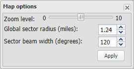
Select a zoom level between 0 and 10. This zoom level is only applied when you select to zoom to an item on any of the tabs on the Data view, such as the CDR data, Sector data or Public records tabs.
Select the size that you want the sector radiuses displayed on the map. The available range is 0.1 to 30 miles. This sets the radius for all the sectors, however you can set each sector radius individually by right-clicking the sector, then clicking Sector properties... to open the Sector Information dialog box.
Select the size that you want the sector beam widths displayed on the map. The available range is 1 to 360 degrees. This sets the beam width for all the sectors, however you can set each sector beam width individually by right-clicking the sector, then clicking Sector properties... to open the Sector Information dialog box.
Click to apply any changes you have made to the map options.